Encyclopedia

geostationary

Also found in: Dictionary, Financial, Acronyms, Wikipedia.

geostationary

Aligned with the earth. Refers to geostationary earth orbit (GEO) satellites that revolve around the equator at the same rotational speed as the earth. Appearing as though they are not moving at all, GEOs are always above the same location on the planet. Three GEO satellites cover the earth's surface. See geosynchronous and GEO.


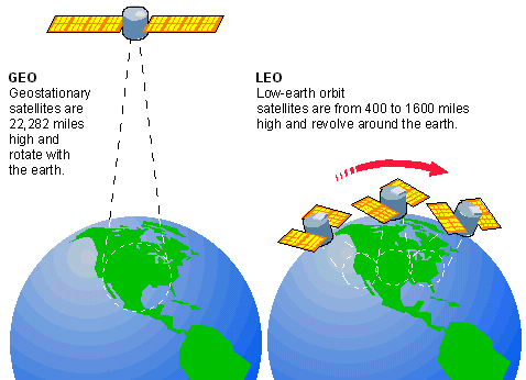
GEOs Travel With the Earth
Geostationary satellites travel at earth speed and are always in the same place above the earth. They also cover a large geographic area.
Copyright © 1981-2025 by The Computer Language Company Inc. All Rights reserved. THIS DEFINITION IS FOR PERSONAL USE ONLY. All other reproduction is strictly prohibited without permission from the publisher.
Mentioned in
References in periodicals archive
Ariane 5 will be at the ready for this mission, once again confirming its role as the champion for launches toward geostationary orbit.'
With a focus on desert dust, biomass burning, and other anthropogenic pollutants over northeast Asia, researchers utilized data from the Geostationary Ocean Color Imager on the Korea Aerospace Research Institute's Communication, Ocean, and Meteorology Satellite (COMS) currently monitoring that region.
While INSAT-3DR will be positioned in geostationary orbit and is expected to be ready by June 2015, GISAT is still in the preparatory stage.
EGNOS is used in Europe to improve airport access for aviation and consists of a range of geostationary satellites and a network of ground reference stations.
Even though there may be a gap in backup coverage, NOAA has not established adequate continuity plans for its geostationary satellites.
Naval Department publication, presents research on current work to build and operate smaller satellites with current technology for use near geostationary orbit.
Since the 1980s, however, most launch vehicles have been optimized to send payloads to a "geostationary transfer orbit," with a low perigee and an apogee near 22,240 miles (35,800 km), to serve the communications-satellite industry.
Thales TopFlight SDU will use the SwiftBroadband service provided by Inmarsat's 14 geostationary satellites to route calls and data to the ground.
Copyright © 2003-2025 Farlex, Inc Disclaimer
All content on this website, including dictionary, thesaurus, literature, geography, and other reference data is for informational purposes only. This information should not be considered complete, up to date, and is not intended to be used in place of a visit, consultation, or advice of a legal, medical, or any other professional.