horizon
horizon
Horizon
(religion, spiritualism, and occult)The term horizon has the same meaning in astrology as in other contexts, although in astrological practice it usually refers only to the eastern and western horizons. Extended out into space and projected against the background of the stars, the eastern horizon is referred to as the ascendant, which is the same as the cusp of the first house. Similarly, the western horizon projected against the background of the stars is the descendant, which is also the cusp of the seventh house. A distinction can be made between the tropocentric horizon, which is the horizon from a particular spot on the surface of Earth, and the geocentric horizon, which is a “horizon” created by drawing through the middle of Earth an imaginary line (or great circle) that is parallel to the tropocentric horizon. When extended out into space, the geocentric horizon is called the rational horizon. For most astrological work, the difference between the tropocentric horizon and the geocentric horizon is insignificant.
Sources:
horizon
[hə′rīz·ən]horizon
horizon

ii. When an apparent boundary is modified by refraction, terrain, or other factors, it is called an apparent horizon.
iii. A small circle on the celestial sphere, the plane of which passes through the observer's eye and is parallel to the observer's rational horizon, is called a sensible horizon.
iv. A path followed by a radar beam when it is tangential to earth is a radar horizon.
v. The locus of the point at which direct rays from a terrestrial radio transmitter become tangential to the earth is a radio horizon.
vi. A line resembling the visible horizon but above or below it is called a false horizon.
vii. An artificial horizon is a gyroscopic instrument for indicating the attitude of an aircraft with respect to the horizontal. See artificial horizon.
Horizon
the part of the earth’s surface that is visible to the eye of an observer on open terrain. The line along which the sky appears to be contiguous with the earth’s surface is called the visible horizon (see Figure 1). The distance d of the visible horizon, that is, the distance to the most distant visible points of the earth’s surface, depends on the altitude h of the observer’s location above the level of the surrounding terrain and on the relief of the terrain (at sea it depends on the elevation above sea level); it is expressed by the formula d (in ![]() (the mean refraction is taken into account in the formula). With an increase in altitude h the distance of the visible horizon increases (see Table 1).
(the mean refraction is taken into account in the formula). With an increase in altitude h the distance of the visible horizon increases (see Table 1).
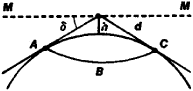
The true, or mathematical, horizon is a large circle of the celestial sphere whose plane is perpendicular to a plumb line. The visible horizon usually lies lower than the true horizon, and the angle δ between them is called the lowering of the horizon.
| Table 1. The visible horizon in terms of height and distance | |||||
|---|---|---|---|---|---|
| h(m) | d(km) | h(m) | d(km) | h(m) | d(km) |
| 1 | 3.8 | 9 | 11.5 | 80 | 34.3 |
| 2 | 5.4 | 10 | 12.1 | 90 | 36.3 |
| 3 | 6.6 | 20 | 17.1 | 100 | 38.3 |
| 4 | 7.7 | 30 | 21.0 | 200 | 54.2 |
| 5 | 8.6 | 40 | 24.2 | 300 | 66.3 |
| 6 | 9.4 | 50 | 27.1 | 400 | 76.6 |
| 7 | 10.1 | 60 | 29.7 | 500 | 85.6 |
| 8 | 10.8 | 70 | 32.0 | 600 | 93.8 |
The meridian of the place of observation intersects the true horizon at north and south points. Between them on the horizon lie the east point (to the right of the observer who stands facing north) and the west point (to his left). At the east and west points the horizon intersects with the celestial equator. The points north, east, south, and west are called the main points of the horizon.
N. P. ERPYLEV [7–23l–1]
Horizon
in geology, a local stratigraphic subdivision corresponding to a level or sublevel of the generally accepted stratigraphic scale. It includes rocks of the same age with varied lithological composition, sometimes with a definite set of fauna (for example, the Chokrak horizon of the Neocene in the Crimean and Caucasian area). Sometimes the term “horizon” is used to designate a patch of layers of little thickness with distinctive lithological or paleontological features that is well-traced along its course (for example, a horizon with silicic concretions, a coral horizon).
Horizon
a research ship of the Scripps Institution of Oceanography of the University of California (USA).
The Horizon was built in 1944. It is 43.6 m long and 10 m wide, with a 900-ton displacement and a top speed of 25 km per hour. It can cruise autonomously for 48 days, with a range of about 13,000 km. It is equipped with sounding devices, two hydrographic winches, a trawl winch, a bathythermographic winch, and a scientific laboratory. The Horizon was designed for meteorologic and all types of oceanographic observations; it has been used to investigate various regions of the Pacific Ocean. In 1952–53 an expedition on the Horizon discovered the Tonga trough, the greatest depth known to that time (10,633 m).