Direction Finding
determining the direction to some object in terms of angular coordinates, which may be reckoned either with respect to the planes of the true horizon and the meridian or with respect to planes that are otherwise oriented in space. Coordinates of the latter type are called grid coordinates. Depending on the physical properties of the objects observed, direction finding may be accomplished by sighting methods (optical direction finding), by radioengineering methods (radar), or by acoustic methods (sonar).
When finding a direction, a sighting device, directional antenna, or some similar device is pointed at the object S being observed
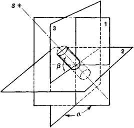
(see Figure 1). The mutually perpendicular principal planes 1 and 2 to which the readings of the measured angles are referred are stabilized in space by means of optical, gyroscopic, or optical-mechanical stabilizing systems. The measured coordinates are the angle β between principal plane 2 and the axis of the sighting device or antenna, and the bearing angle a between sighting plane 3 and principal plane 1 (plane 3 is a plane passing through the observed object and perpendicular to principal plane 2). The values of the angles are transmitted via a telemetering system to a registering or computing device and are read off the scale of a measuring instrument. In marine navigation, usually only angle a, that is, the bearing of the object, is determined.
The possibility of finding the direction to an object depends in part on the contrast between the object and its background; that is, it depends on differences in the physical properties of object and background. In passive direction finding, the natural contrast of the observed object is used. In active direction finding, the object is irradiated by electromagnetic or acoustic waves from an artificial radiation source, and the reflected radiation or retransmitted signals are observed. One method of active direction finding, for example, uses laser radiation.
Direction-finding equipment is classified as being either of the amplitude or the phase type, depending on the method of processing the received signals. With the amplitude method, spatial orientation of the directivity pattern of the transmitting or receiving antenna is changed for the purpose of the direction findings and the direction to the observed object can be determined either from the maximum or minimum amplitude of the received signal or by a comparison of the two amplitudes. With the phase method, spaced antennas that are stabilized along the principal planes are used as receivers. The quantity measured is the phase difference between the signals received by the antennas, which depends on the angular coordinates of the object.
In order to compensate for systematic measuring error, corrections are made when the direction-finding system is being aligned. Random errors in direction finding are a function of the ratio between the wavelength of the received radiation and the linear dimensions of the antenna. They are also influenced by such factors as the direction-finding method, the noise level, the receiver sensitivity, and the accuracy with which the mechanical subassemblies of the equipment have been fabricated.
Direction finding is used extensively in navigation to determine the positional parameters and trajectory of various terrestrial, marine, aerial, and celestial objects. Its principles are used in systems for preventing collisions between ships on the high seas or between aircraft. They are used in guidance systems for weapons and for controlling the flight and landing patterns of airplanes. They are also used in the rendezvousing and docking of spacecraft and in determining corrections for navigation instruments and systems used in these maneuvers.
In meteorology, direction-finding methods are used to determine the area and nature of cloud cover and precipitation, the regions of thunderstorm formation, and the location of tropical cyclones that are potential navigational hazards. By finding the direction of radiosondes released in the atmosphere, the velocity and direction of air currents at different heights are measured. Similarly, the direction of freely drifting objects is used to determine the velocity and direction of ocean currents.
REFERENCES
Popeko, G. P., and E. P. Solomatin. Navigatsiia. Leningrad, 1961. (Kurs korablevozhdeniia, vol. 1.)Kosmicheskie traektornye izmereniia: Radiotekhnicheskie metody izmerenii i matematicheskaia obrabotka dannykh. Moscow, 1969.
Osadshii, V. I. Vozdushnaia navigatsiia. Moscow, 1972.
Mezhdunarodnye pravila preduprezhdeniia stolknovenii v more. Moscow, 1973.
M. I. SKVORTSOV and N. S. TOROPOV